Friday, April 6, 2018

Why Can't the Nuclear Bailout Bills Expand Radiological Preparedness in NJ?


Based on the latest article at NJSpotlight.com, it looks like the vote for the nuclear bailout is going to be a done deal with the Senate, Assembly, and Governor.

If the nuclear bailout bill (presently S2313/A3724, I think) is a fait accompli then the Murphy administration may want to consider requiring PSEG (and Excelon?) to increase the radius of their Emergency Planning Zones in NJ from the NRC-mandated 10 miles to 50 miles.
Some of the reasons why we need a 50-mile EPZ were explained back in 2015 in NJSpotlight.
Another reason: a substantive mandate for radiological terrorism preparedness throughout the state is still missing from the NJ Radiological Emergency Response Plan.
N.J.S.A. 26:2D-37, and other sections of the Radiation Accident Response Act, specifically limit the definition of an emergency response to a radiation accident to one that occurs (1) at a nuclear facility or (2) during a transportation accident. There is no specific mandate to develop  specific plans for responding to a nuclear disaster if it is caused by an act of terrorism and it happens outside a 10-mile Emergency Planning Zone. That's nuts.
The generous funding in these bills is more than enough to fund the mandated drills, equipment and training within a 50-mile EPZ – like it presently does within the current 10-mile EPZ. This would effectively expand the requirement for nuclear preparedness planning beyond two or three 10-mile zones into much of NJ.
If this suggestion is not included in the final bills that end up on the Governor's desk, then his  NJDEP should at least consider funding a pilot program for counties that are within the hypothetical 20-mile Dangerous Fallout Zone surrounding major urban centers within or proximate to NJ (1). The radiological planning documents already developed for the 10-mile EPZ could be provided to communities within the 20-mile DFZ in order to cost-effectively kick-start this planning.
The US GAO has been warning for years in multiple reports that the “government isn't fully prepared to handle a nuclear terrorist attack or a large-scale natural catastrophe, lacks effective coordination, and in some cases is years away from ensuring adequate emergency shelter and medical treatment”.
The US DHHS Office of Inspector General has also warned: “Although the Nuclear Regulatory Commission requires nuclear power plants to have emergency plans for their facilities and the immediate surrounding area, no Federal entity requires States or localities to have public health emergency plans for nonpowerplant radiological and/or nuclear (RN) incidents, such as a terrorist attack.”
This administration has walked into an opportunity to start fixing this. Batter up.
(1) The Dangerous Fallout Zone (DFZ) from a 10 kt bomb temporarily peaks at 10,000 mille Roentgens/hour, or about a million times ambient background radiation (in coastal NJ) at twenty miles from ground zero. Planning Guidance for Response to a Nuclear Detonation (2nd Ed. p.32) (NSSOSTP, 2010) http://www.remm.nlm.gov/PlanningGuidanceNuclearDetonation.pdf


Monday, February 12, 2018

Partial Plant List for Horseshoe Cove at Sandy Hook


White Campion, June and September
This is an initial list of plants at Horseshoe Cove, Sandy Hook NJ.

These pictures – and over 6 million observations worldwide - have been geolocated and posted at iNaturalist.org. You can zoom-in to Horseshoe Cove to see a map of icons representing groups of species, like plants, birds, fish, shells, etc.

All the plant names in this post are linked to a great website for identifying plants in maritime habitats like Sandy Hook, “Cape May Plants – An Identification Guide” by CapeMayWildlife.

TREES/SHRUBS

Autumn Olive, Hackberry (winter), Groundsel
Autumn Olive (Elaeagnus umbellata)

Eastern Redcedar (Juniperus virginiana) Pictures at previous blog A Dune Garden at Sandy Hook .

Common Hackberry (Celtis occidentalis)

Groundsel Tree (Baccharis halimifolia)

Marsh Elder (Iva frutescens) Picture below.

Northern Bayberry (Morella pensylvanica) Pictures at previous blog A Dune Garden at Sandy Hook .


GRASS

Salt Marsh Cord Grass, Marsh Elder, Salt-meadow Cord-grass at HSC
Salt Marsh Cord Grass (Spartina alterniflora)

Salt-meadow Cord-grass (Spartina patens)

Bitter panic grass, Little bluestem, Purpletop
Bitter Panic-grass (Panicum amarum var. amarulum)

Little Bluestem (Schizachyrium scoparium) Pictures at previous blog A Dune Garden at Sandy Hook .
Purpletop (Tridens flavus)


IVY

Poison ivy, honeysuckle, fuzzy-bean
Eastern Poison-ivy (Toxicodendron radicans)

Japanese honeysuckle (Lonicera japonica)

Trailing fuzzy-bean (Strophostyles helvola)


FLOWERS

White

5 petals

Soapwort. Multiflora rose (fruit only) in April, and May flowers
Common soapwort (Saponaria officinalis) (also pink)

Multiflora rose (Rosa multiflora)

White campion (Silene latifolia) Picture at the beginning of this post.

Many-flowered Heads

Queen Ann's lace, pepperweed, sweetclover
Queen Anne's lace (Daucus carota)

Virginia pepperweed (Lepidium virginicum)

White sweetclover (Melilotus albus)


Yellow

4 Petals

Common Evening-Primrose (Oenothera biennis) Pictures in a previous blog, A Dune Garden at Sandy Hook .

Great mullein (before flowered stalk), Land cress, Black medick
5 Petals

Great mullein (Verbascum thapsus)

Many-flowered Heads

Black medick (Medicago lupulina)

Land cress (Barbarea verna)

Seaside Goldenrod (Solidago sempervirens) Pictures in a previous blog, A Dune Garden at Sandy Hook .

More Than 6 Petals

Eastern Prickly-pear (Opuntia humifusa) Pictures in a previous blog, A Dune Garden at Sandy Hook .


Red/Pink

5 Petals

Stork's-bill and Herb Robert
Common stork's-bill (Erodium cicutarium)

Herb Robert (Geranium robertianum)

Rugosa (flowers & unripened fruit, June), Swamp Rose (fruit only, Apr), & Sp. Knapweed (June)
Rugosa rose (Rosa rugosa) (also white)

Swamp rose (Rosa palustris)

Many-flowered Heads

Spotted knapweed (Centaurea stoebe)


Purple

Alfalfa (without flower), Scorpion Grass
Many-flowered Heads

Alfalfa (Medicago sativa)


Blue

5 Petals

Blue scorpion grass (Myosotis stricta)


Green

Mugwort (Aug.), Dock (Sept.), wild garlic (with flower, June)
Many-flowered Heads

Common mugwort (Artemisia vulgaris)

Curled Dock (Rumex crispus)

Wild garlic (Allium vineale)

The Amaranths and related species with green flowers at Horseshoe Cove (and Plum Island) are discussed in a previous blog, Salt Marsh Scrub At Sandy Hook NJ .

Followup

Common names vary, so use the Latin scientific name to Google more images.

NY-NJ-CT Botany Online has biota lists for many of the parks in our area, including a plant list for Sandy Hook.


Monday, February 5, 2018

A Dune Garden at Sandy Hook


There is an observation deck over the pavillion at the North Beach at Sandy Hook, and the view of Manhattan is spectacular.

Turn around. That's the Sandy Hook lighthouse gleaming over the treeline of one of the largest maritime forests in NJ. The lighthouse was only 500 feet from the shoreline when it was built in 1764; now it's about a mile and half away.

It's hard to believe all that land came from grains of sand that washed up the coast from Manasquan, blew onshore, and was trapped by tiny plants then bigger ones as it gradually built up into a dune.


Later, you can read about Littoral Drift, the Nearshore, Foreshore, and Backshore zones of the beach, and Primary and Secondary dunes; this blog is about the plants. The NPS built a boardwalk from the deck so you can walk down through the dunes and take a look at them on your way to the beach.

1. The Classics

American Beachgrass (Ammophila breviligulata)


Beachgrass is a pioneer species that promotes the continual growth of the dunes because it grows back after it's been buried by sand. Its roots (rhizomes) trap and stabilize sand (the roots are exposed at the bottom of the picture on the right). It's highly resistant to salt spray, but is vulnerable to trampling. It is commonly used when planting dune grass for Coastal resiliency.

Asiatic Sand Sedge (Carex kobomugi)


This invasive nemesis of American Beachgrass out-competes it by forming a monoculture that is less damaged by trampling. There is some evidence it may be effective at preventing erosion during large storms like Superstorm Sandy. The “large, club-shaped flowerhead and broad, strongly recurved leaves are distinctive”. The picture on the right was taken in January.

Seaside Goldenrod (Solidago sempervirens)


This flower starts lighting up Sandy Hook in late summer and attracts migrating Monarch butterflies during the fall. It prefers sandy, salty soil and has fleshy leaves for storing water. Its heavy pollen doesn't cause hay fever. The middle picture was taken at Horseshoe Cove at Sandy Hook, and the picture on the right was taken in April of a sprout growing by a dead goldenrod, probably from a shared “short, stocky”rhizome.

Beach Plum (Prunus maritima)


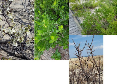
The beach plum is native to the northeast coast from Newfoundland to North Carolina, with most found from northern Massachusetts to southern NJ. Because it is salt tolerant and deep rooted, it is one of the dominant shrubs on coastal dunes. In spring it produces showy white blossoms so prominent they can be tracked with arial surveys. Berries ripen red and purple and can be harvested for jams in the late summer and fall. Henry Hudson noted the thickets of blue plums along the banks of the Hudson River in 1609 that Giovanni de Verrazano had called “damsel trees” in 1524. From left to right the pictures show early spring flowers, unripened berries and egg-shaped (ovate) leaves, ripening berries, and withered winter berries. (A picture of a beach plum is also at the beginning of this post.)

Northern Bayberry (Morella pensylvanica)


This other prominent coastal dune shrub looks a little like the beach plum at first. The bayberry has an oblong (specifically oblanceolate, oblong, obovate) leaf shape that is narrower than the more egg-shaped (ovate or obovate) leaf of the beach plum. (It has yellow resin dots on the underside of the leaf, while the southern variety, the wax myrtle, has them on both sides.) The fragrant wax from the bayberry fruit is used to make candles. The blue-grey fruit is at the bottom of the picture on the left.

Eastern Prickly-pear (Opuntia humifusa)


The only native cactus in NJ. By June its yellow flowers gleam throughout the Park's scrub and waysides, briefly, then are replaced with a red fleshy fruit. Its flat, bristly stems are called paddles, and are “used in the South in breakfast omelets”. Hmm.

Eastern Redcedar (Juniperus virginiana)


This conifer is common to coastal dunes, as well as being a pioneer species of disturbed ground. Prickly needle-shaped leaves on young plants become overlapping scales on mature trees that provide shelter for birds. The color of its waxy fruit changes from pale-green to dark blue by mid fall. The berries are an important source of food for birds during the winter (it is where the cedar waxwing, which is common to Sandy Hook, gets its name). Redcedars were used by colonists to flavor gin; gin is either from the "French genièvre or the Dutch jenever, which both mean juniper”. The Army used to guard the redcedar and holly trees from being chopped down for Christmas decorations. The picture on the right, taken during a ranger-led walk through the Holly Forest, shows why this juniper is mistakenly called a cedar.

2. Deeper Dive

Little Bluestem (Schizachyrium scoparium)


A very common field weed . The distinctive, fluffy white seed heads start blooming in mid summer and continue through the fall. Seed heads are purple when emerging. Very similar to Broomsedge bluestem (Andropogon virginicus) except:

“Little Bluestem has flower or seed stalks that extend out beyond any leaves on the stem. [ Andropogon virginicus] flowerheads or seedstalks are tucked into enclosing leafy bracts. In the non-seeding seasons, Little Bluestem can often be identified by plucking off a central stem at the base, at the soil level. Little Bluestem stem bases tend to be reddish, while [Andropogon virginicus] stem bases are white.”

And it's also similar to Coast Beard-grass (Schizachyrium littorale)! (Grass identification can be a heavy lift.)


Sandy Hook has the largest known population of this state-listed plant in NJ (S2 - Imperiled), according to a 2012 report by the NJDEP. The second largest is also in Monmouth County, in the dunes west of the Keansburg boardwalk. In the picture on the left, you can see the two distinctly different-looking growth stages. It begins with narrowly oblong basal leaves, and matures into "paniculiform arrays" of flowerheads (this website has pictures of both stages as well). The picture on the right was taken in January at the sand fence near the beginning of the beach path from the pavilion. Another species of wormwood, Artemisia absinthium, is used as an ingredient in absinthe, bitters, and vermouth

Winged Pigweed (Cycloloma atriplicifolium)


That name. Pigweed can mean several members of the Amaranthus family that were used as pig fodder. “Surrounding each group of sepals and the seed, there is a pale membranous wing (wider than 0.5 mm.) that is circular and slightly fringed along its outer margin.” The wings are the dots along the stems in the picture on the left. The picture on the right is an alien landscape of pigweed covering a dune next to Waackaack Creek in Keansburg. Pigweed becomes a tumbleweed when it dries up in the fall.

Common Milkweed (Asclepias syriaca)


Several have been planted in a corner near the end of the wooden ramp. Monarch butterfly populations have declined by 90% in the last 20 years, so the National Wildlife Federation has been promoting milkweed-planting throughout the monarch's migratory paths, that include Sandy Hook. Monarchs will only lay their oval, off-white eggs (scroll down) on the underside of the milkweed leaf. The picture on the right is of the seed husks in January. Last summer there was a single orange Butterfly Milkweed (Asclepias tuberosa) blooming in the scrub on the bayside dune across from Parking Lot A (just past the toll-booths at the entrance).

Common Evening-Primrose (Oenothera biennis)


Common and widespread, flowering from June to October. It has four yellow petals and a distinctive seed pod that turns woody on larger plants in the winter. Seeds contain gamma linolenic acid, an anti-inflammatory compound. In its first year this biennial typically produces a leafy basal rosette with a white mid-vein but no flowers. That's the picture on the left. The two on the right were taken in January at the sand fence near the beginning of the beach path from the pavilion.

Sandspur (Cenchrus sp.)


Stickers. “Nature's hitchhikers”. Two species common to both the primary and secondary dunes are Dune Sandspur (Cenchrus tribuloides) and Mat Sandspur (Cenchrus longispinus). Here's how to tell the difference: tribuloides is hairier between the spines, and has less than 43 spines; longispinus has 45 or more (enjoy!). The picture on the right was taken in January. There are some nice off-season pictures on the Maryland Biodiversity Project (MBP) website of tribuloides and longispinus.

These pictures – and over 6 million observations worldwide - have been geolocated and posted at iNaturalist.org. You can zoom-in to Horseshoe Cove to see a map of icons representing groups of species, like plants, birds, fish, shells, etc.

A great website for identifying plants in maritime habitats like Sandy Hook is “Cape May Plants – An Identification Guide” by CapeMayWildlife (most of the plant names are linked to it). Another site, “NY-NJ-CT Botany Online” has biota lists for many of the parks in our area, including a plant list for Sandy Hook.


Friday, January 26, 2018

Salt Marsh Scrub At Sandy Hook NJ

The salt marsh scrub along the bay side of Sandy Hook occurs in tidal and higher, irregularly flooded habitats. This blog identifies some of these moderately halophilic plants, including a few salt bushes (not grasses or trees in this post) from photos taken at Horseshoe Cove and Plum Island.

These pictures – and over 6 million observations worldwide - have been geolocated and posted at iNaturalist.org. You can zoom-in to Horseshoe Cove to see a map of icons representing groups of species, like plants, birds, fish, shells, etc.

The plant names in this post are linked to a great website for identifying plants in maritime habitats like Sandy Hook, “Cape May Plants – An Identification Guide” by CapeMayWildlife.  NY-NJ-CT Botany Online has biota lists for many of the parks in our area, including a plant list for Sandy Hook.

Common names vary, so use the Latin scientific name if you want to Google more images.


Horseshoe Cove

After leaving the path from the salt marsh bridge, walk north towards Battery Arrowsmith along the wetlands above the beach.

Sea Lavender (Limonium carolinianum)


The left picture shows the typical lavender-colored mature plant at the top, and the leafy sprout at the bottom, covered with some type of white powdery-mildew, that is a common Limonium pest. The picture on the right is what it looks like before it turns lavender. A lot of these lavenders bloom around the boardwalk at Spermaceti Cove.

Sea Blight (Suaeda maritima)


Look for both succulent spikelets and seed-like balls along the stems (it looks a little like spiky ragweed). The technical names for these parts may be in this link, along with a nice close-up. Suaeda is Arabic for black salt, which is the color of its extracted salt after drying (same link). Sea Blight is a lallation issue for Sea Bright.

Pickleweed (Salicornia sp.)


"Fetches more than $5 a pound at the Berkeley Bowl grocery.” Local species include Virginia Glasswort and Common Glasswort. Lots by Spermaceti boardwalk.

Marsh Elder (Iva frutescens)


After you cross the road from the Horseshoe Cove parking lot, look on the right (to the north) for an opening in the brush. You will see three distinct zones in the salt marsh that is caused by the frequency and duration of tidal flooding. Marsh Elder is the hedge in between two grasses: Saltmarsh Cordgrass (Spartina alterniflora), which is most adapted to living in saline water, and Saltmeadow Hay (Spartina patens), at the edge of the semidiurnal flooding, just below the treeline. The treeline is where a lens of freshwater (from rain) floats on the saline groundwater and the maritime forest begins.

Plum Island

Besides these plants, Plum Island also has three salt bushes. Salt bushes thrive in salt marshes because they secrete excess salt to maintain their internal salt balance (they are also well adapted to deserts). All three species are listed by NY-NJ-CT Botany Online for Sandy Hook.

Crested Orache (Atriplex mucronata)


Along the main path across from Parking Lot B, as it curves along the tidal cove to the north (on the right). Below a long hedge of Marsh Elder. The picture on the right shows the flower spike and the distinctive “spiky fruiting bodies”.

Spear-leaved Orache (Atriplex prostrata)


Along the main path across from Parking Lot B, well past where it curves along the tidal cove to the south (on the left). Note the triangular leaves.

Fivehorn smotherweed (Bassia hyssopifolia)


Same area as Atriplex mucronata, as well as further to the northwest along the path. The picture on the right shows the 5 horns.

These plants can be found at other locations in Sandy Hook, as well as in some towns along the Bayshore that still have intact salt marsh habitat. Log into iNaturalist and zoom in for exact locations.


Tuesday, January 2, 2018

Are Any Organizations Tracking Transparency Problems with the LSRP Program for the Murphy Transition?

The NJ Licensed Site Remediation Program (LSRP) was initiated in 2009 under Governor Corzine but fully implemented in 2012 under Christie. A concern has been that privatizing environmental cleanups would exempt records from OPRA, since those records are being maintained by the private sector rather than the NJDEP. This is discussed here, here, and here.

In 2012, the NJDEP published a convoluted policy to band-aid this problem “
NJDEP Site Remediation Public Inquiry Policy Document October 2012”.

How well is this working? I recently spoke with someone who was trying to get some information about a groundwater plume and was told by the NJDEP they didn't track that anymore. They told him to call the LSRP, who initially told him he would have to wait a year and a half for a final report. After much angst (including plowing through the NJDEP's complicated online search program, Dataminer), he resolved it by eventually finding out (on his own, not from the DEP or the LSRP) that his problem fell into the category "substantial public interest" in Section VI on page 4 of the DEP inquiry policy. When he announced to the DEP and LSRP that he was going that route (getting 25 signatures for a petition) the LSRP gave him "additional outreach" – i.e., he started answering his questions.

My take-home message from all this was wow, what a waste of time just to get to “reasonable”. I Googled "substantial public interest" and found only one other example of someone initiating this: a letter from the Kingswood EC in Hunterdon County on April 7, 2017 petitioning the DEP to assist getting more outreach from the LSRP for a salt plume as per NJAC 7:26 C-1.7(o) 
http://www.nj.gov/dep/srp/community/sites/hunterdon/active/petition_for_public_interest.pdf .

Perhaps the transparency problem I am describing is not common, and the system is mostly working well for the public (is the LSRP privatization really New Jersey’s quiet environmental accomplishment, or not?).

However, while the Kingswood letter and the policy are posted on the NJDEP's “Community Relations Site Lists” page, it is way too buried for a member of the public to easily become aware of their rights and options for getting information or updates about local contaminant plumes. This kind of transparency is less like public access and more like a data dump.


At a minimum, DEP staffers should be directing the public to their inquiry policy, not just telling them to call the LSRP, and the policy should be prominently published on the NJDEP website. County and Local government should be educated about this as well so they can competently answer questions from the public.


If this problem turns out to be common, it might justify funding:
... an electronic submittal system similar to the one utilized in Massachusetts. New Jersey's LSRP program is very similar to, and was in fact modeled after, Massachusetts' successful Licensed Site Professional (LSP) program. Recognizing the need for transparency, the Massachusetts DEP (MassDEP) set up an online filing system known as eDEP, which allows LSPs to upload submittals electronically and makes the information publicly available through a searchable database. MassDEP also scanned all the prior reports into PDFs and made them available online. By comparison, LSRPs submit forms (and, on occasion, reports) to the NJDEP in hard copy, which is stored in the NJDEP's central file along with any pre-LSRP reports, and are available for review only upon written request (and payment of related fees).”

Dataminer will need a major overhaul not just a tweak to make this work. Now, if you just want to review the work of a particular LSRP, you:


  • Click “Search by Category”
  • Select Site Remediation as the “Report Category”.
  • You are on the Site Remediation Report page. Half way down is “LICENSED SITE REMEDIATION PROFESSIONAL INFORMATION”.
  • Click on “Licensed Site Remediation Professional List”. It's alphabetical, so you can page through 29 links, or export it to a pdf or Excel spreadsheet. When you find their name, write down their License Number.
  • Go back to the Site Remediation Report page. Scroll down to “LICENSED SITE REMEDIATION PROFESSIONAL INFORMATION”. Click on “License Site Remediation Professional Comprehensive Report” and enter the LSRP number.
Good luck with the Acronyms etc once you get there. I have written about how hard it is to use Dataminer to dig up information about discharges from Combined Sewer Outfalls in a previous blog.


Thursday, September 1, 2016

Minecraft-worthy Geology In The Wrack Line At Sandy Hook, NJ – Part 5 of 5: Coal and Tarballs

                                                          Coal; Jetty rock w oil

Coal

Chunks of coal, as well as slag from burned coal and smelted iron, are found in the bay and ocean wrack lines at Sandy Hook.

Coal had been an important source of heat in public buildings and power plants until the late 1960’s. Most of the coal washing up on the beach came from spillage from ships, or from dumped “cellar ash”. Some of it may be from “sea coal” carried along the coast from rivers in the Appalachian coal fields and from the Valley and Ridge province long before it was mined. It was abundant enough on Long Island beaches that a permit was issued in 1677 to locate significant deposits.

With more pressure, heat and time, peat transforms into lignite, bituminous, and eventually, anthracite coal. Most coal was formed in peat or coal swamp forests (scroll down to The Coal Age) about 300 million years ago during the Carboniferous Period:

Coal forms from the accumulation of plant debris, usually in a swamp environment. When a plant dies and falls into the swamp, the standing water of the swamp protects it from decay. Swamp waters are usually deficient in oxygen, which would react with the plant debris and cause it to decay. This lack of oxygen allows the plant debris to persist.” When this layer of peat is buried by sediments, the weight “compacts the plant debris and aids in its transformation into coal. About ten feet of plant debris will compact into just one foot of coal.”

Some chunks may also be lignite deposits from the Raritan-Magothy Formation where it outcrops along Raritan Bay in Middlesex County. Recently formed peat from tidal flats and salt marshes can also be seen in the wrack line after storms, and cedar peat deposits have been found in cores of the seafloor a few hundred feet off coastal lakes in Monmouth County. Here are more pictures of peat, lignite and coal; scroll down for a picture of peat with clam borings found on a beach in Long Island.

Tarballs

While most coal was formed from peat swamps about 300 million years ago, oil and natural gas were formed from plankton, most of it from 252 to 66 million years ago.

Black round tarballs from oil spills from refineries along Raritan Bay and oil tankers can periodically be found in the wrack line at Sandy Hook. About 21 billion gallons oil transported by marine tankers passed under the Verrazano Bridge in 2010, as reported in “A Stronger, More Resilient New York” (p134, pdf-p 4).

Scientists from the University of Utah have calculated that it takes 98 tons of these buried prehistoric plants to produce a single gallon of gasoline. They also found that the amount of fossil fuel burned in one year is equivalent to "'all the plant matter that grows in the world in a year,'" including vast amounts of microscopic plant life in the oceans.”

Volcanoes were a major source of the carbon dioxide in the atmosphere during the period of geologic time known as “Greenhouse Earth”. A superplume caused by abundant volcanoes produced 4000 ppm of carbon dioxide and other greenhouse gases that melted the icecaps during the Cretaceous and put the NJ coastline between the Watchung Mountains and Rt 1 (scroll to Figure “Generalized geographic map of the United States in Late Cretaceous time”).

Currently, carbon dioxide produced by fossil fuels is about 130 times present volcanic emissions, but just one tenth of the catastrophic super-plume levels of the Cretaceous.

Widespread scientific consensus exists among scientists that are experts in the field of climate studies that the world’s climate is now changing (NASA) faster (NOAA) due to burning so much of these plant-derived fossil fuels.

The other four blogs are at http://pehealthnj.blogspot.com/ .