Friday, January 26, 2018

Salt Marsh Scrub At Sandy Hook NJ

The salt marsh scrub along the bay side of Sandy Hook occurs in tidal and higher, irregularly flooded habitats. This blog identifies some of these moderately halophilic plants, including a few salt bushes (not grasses or trees in this post) from photos taken at Horseshoe Cove and Plum Island.

These pictures – and over 6 million observations worldwide - have been geolocated and posted at iNaturalist.org. You can zoom-in to Horseshoe Cove to see a map of icons representing groups of species, like plants, birds, fish, shells, etc.

The plant names in this post are linked to a great website for identifying plants in maritime habitats like Sandy Hook, “Cape May Plants – An Identification Guide” by CapeMayWildlife.  NY-NJ-CT Botany Online has biota lists for many of the parks in our area, including a plant list for Sandy Hook.

Common names vary, so use the Latin scientific name if you want to Google more images.


Horseshoe Cove

After leaving the path from the salt marsh bridge, walk north towards Battery Arrowsmith along the wetlands above the beach.

Sea Lavender (Limonium carolinianum)


The left picture shows the typical lavender-colored mature plant at the top, and the leafy sprout at the bottom, covered with some type of white powdery-mildew, that is a common Limonium pest. The picture on the right is what it looks like before it turns lavender. A lot of these lavenders bloom around the boardwalk at Spermaceti Cove.

Sea Blight (Suaeda maritima)


Look for both succulent spikelets and seed-like balls along the stems (it looks a little like spiky ragweed). The technical names for these parts may be in this link, along with a nice close-up. Suaeda is Arabic for black salt, which is the color of its extracted salt after drying (same link). Sea Blight is a lallation issue for Sea Bright.

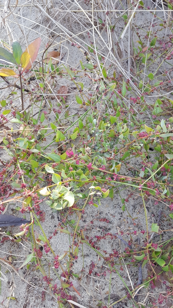
Pickleweed (Salicornia sp.)


"Fetches more than $5 a pound at the Berkeley Bowl grocery.” Local species include Virginia Glasswort and Common Glasswort. Lots by Spermaceti boardwalk.

Marsh Elder (Iva frutescens)


After you cross the road from the Horseshoe Cove parking lot, look on the right (to the north) for an opening in the brush. You will see three distinct zones in the salt marsh that is caused by the frequency and duration of tidal flooding. Marsh Elder is the hedge in between two grasses: Saltmarsh Cordgrass (Spartina alterniflora), which is most adapted to living in saline water, and Saltmeadow Hay (Spartina patens), at the edge of the semidiurnal flooding, just below the treeline. The treeline is where a lens of freshwater (from rain) floats on the saline groundwater and the maritime forest begins.

Plum Island

Besides these plants, Plum Island also has three salt bushes. Salt bushes thrive in salt marshes because they secrete excess salt to maintain their internal salt balance (they are also well adapted to deserts). All three species are listed by NY-NJ-CT Botany Online for Sandy Hook.

Crested Orache (Atriplex mucronata)


Along the main path across from Parking Lot B, as it curves along the tidal cove to the north (on the right). Below a long hedge of Marsh Elder. The picture on the right shows the flower spike and the distinctive “spiky fruiting bodies”.

Spear-leaved Orache (Atriplex prostrata)


Along the main path across from Parking Lot B, well past where it curves along the tidal cove to the south (on the left). Note the triangular leaves.

Fivehorn smotherweed (Bassia hyssopifolia)


Same area as Atriplex mucronata, as well as further to the northwest along the path. The picture on the right shows the 5 horns.

These plants can be found at other locations in Sandy Hook, as well as in some towns along the Bayshore that still have intact salt marsh habitat. Log into iNaturalist and zoom in for exact locations.


Tuesday, January 2, 2018

Are Any Organizations Tracking Transparency Problems with the LSRP Program for the Murphy Transition?

The NJ Licensed Site Remediation Program (LSRP) was initiated in 2009 under Governor Corzine but fully implemented in 2012 under Christie. A concern has been that privatizing environmental cleanups would exempt records from OPRA, since those records are being maintained by the private sector rather than the NJDEP. This is discussed here, here, and here.

In 2012, the NJDEP published a convoluted policy to band-aid this problem “
NJDEP Site Remediation Public Inquiry Policy Document October 2012”.

How well is this working? I recently spoke with someone who was trying to get some information about a groundwater plume and was told by the NJDEP they didn't track that anymore. They told him to call the LSRP, who initially told him he would have to wait a year and a half for a final report. After much angst (including plowing through the NJDEP's complicated online search program, Dataminer), he resolved it by eventually finding out (on his own, not from the DEP or the LSRP) that his problem fell into the category "substantial public interest" in Section VI on page 4 of the DEP inquiry policy. When he announced to the DEP and LSRP that he was going that route (getting 25 signatures for a petition) the LSRP gave him "additional outreach" – i.e., he started answering his questions.

My take-home message from all this was wow, what a waste of time just to get to “reasonable”. I Googled "substantial public interest" and found only one other example of someone initiating this: a letter from the Kingswood EC in Hunterdon County on April 7, 2017 petitioning the DEP to assist getting more outreach from the LSRP for a salt plume as per NJAC 7:26 C-1.7(o) 
http://www.nj.gov/dep/srp/community/sites/hunterdon/active/petition_for_public_interest.pdf .

Perhaps the transparency problem I am describing is not common, and the system is mostly working well for the public (is the LSRP privatization really New Jersey’s quiet environmental accomplishment, or not?).

However, while the Kingswood letter and the policy are posted on the NJDEP's “Community Relations Site Lists” page, it is way too buried for a member of the public to easily become aware of their rights and options for getting information or updates about local contaminant plumes. This kind of transparency is less like public access and more like a data dump.


At a minimum, DEP staffers should be directing the public to their inquiry policy, not just telling them to call the LSRP, and the policy should be prominently published on the NJDEP website. County and Local government should be educated about this as well so they can competently answer questions from the public.


If this problem turns out to be common, it might justify funding:
... an electronic submittal system similar to the one utilized in Massachusetts. New Jersey's LSRP program is very similar to, and was in fact modeled after, Massachusetts' successful Licensed Site Professional (LSP) program. Recognizing the need for transparency, the Massachusetts DEP (MassDEP) set up an online filing system known as eDEP, which allows LSPs to upload submittals electronically and makes the information publicly available through a searchable database. MassDEP also scanned all the prior reports into PDFs and made them available online. By comparison, LSRPs submit forms (and, on occasion, reports) to the NJDEP in hard copy, which is stored in the NJDEP's central file along with any pre-LSRP reports, and are available for review only upon written request (and payment of related fees).”

Dataminer will need a major overhaul not just a tweak to make this work. Now, if you just want to review the work of a particular LSRP, you:


  • Click “Search by Category”
  • Select Site Remediation as the “Report Category”.
  • You are on the Site Remediation Report page. Half way down is “LICENSED SITE REMEDIATION PROFESSIONAL INFORMATION”.
  • Click on “Licensed Site Remediation Professional List”. It's alphabetical, so you can page through 29 links, or export it to a pdf or Excel spreadsheet. When you find their name, write down their License Number.
  • Go back to the Site Remediation Report page. Scroll down to “LICENSED SITE REMEDIATION PROFESSIONAL INFORMATION”. Click on “License Site Remediation Professional Comprehensive Report” and enter the LSRP number.
Good luck with the Acronyms etc once you get there. I have written about how hard it is to use Dataminer to dig up information about discharges from Combined Sewer Outfalls in a previous blog.


Thursday, September 1, 2016

Minecraft-worthy Geology In The Wrack Line At Sandy Hook, NJ – Part 5 of 5: Coal and Tarballs

                                                          Coal; Jetty rock w oil

Coal

Chunks of coal, as well as slag from burned coal and smelted iron, are found in the bay and ocean wrack lines at Sandy Hook.

Coal had been an important source of heat in public buildings and power plants until the late 1960’s. Most of the coal washing up on the beach came from spillage from ships, or from dumped “cellar ash”. Some of it may be from “sea coal” carried along the coast from rivers in the Appalachian coal fields and from the Valley and Ridge province long before it was mined. It was abundant enough on Long Island beaches that a permit was issued in 1677 to locate significant deposits.

With more pressure, heat and time, peat transforms into lignite, bituminous, and eventually, anthracite coal. Most coal was formed in peat or coal swamp forests (scroll down to The Coal Age) about 300 million years ago during the Carboniferous Period:

Coal forms from the accumulation of plant debris, usually in a swamp environment. When a plant dies and falls into the swamp, the standing water of the swamp protects it from decay. Swamp waters are usually deficient in oxygen, which would react with the plant debris and cause it to decay. This lack of oxygen allows the plant debris to persist.” When this layer of peat is buried by sediments, the weight “compacts the plant debris and aids in its transformation into coal. About ten feet of plant debris will compact into just one foot of coal.”

Some chunks may also be lignite deposits from the Raritan-Magothy Formation where it outcrops along Raritan Bay in Middlesex County. Recently formed peat from tidal flats and salt marshes can also be seen in the wrack line after storms, and cedar peat deposits have been found in cores of the seafloor a few hundred feet off coastal lakes in Monmouth County. Here are more pictures of peat, lignite and coal; scroll down for a picture of peat with clam borings found on a beach in Long Island.

Tarballs

While most coal was formed from peat swamps about 300 million years ago, oil and natural gas were formed from plankton, most of it from 252 to 66 million years ago.

Black round tarballs from oil spills from refineries along Raritan Bay and oil tankers can periodically be found in the wrack line at Sandy Hook. About 21 billion gallons oil transported by marine tankers passed under the Verrazano Bridge in 2010, as reported in “A Stronger, More Resilient New York” (p134, pdf-p 4).

Scientists from the University of Utah have calculated that it takes 98 tons of these buried prehistoric plants to produce a single gallon of gasoline. They also found that the amount of fossil fuel burned in one year is equivalent to "'all the plant matter that grows in the world in a year,'" including vast amounts of microscopic plant life in the oceans.”

Volcanoes were a major source of the carbon dioxide in the atmosphere during the period of geologic time known as “Greenhouse Earth”. A superplume caused by abundant volcanoes produced 4000 ppm of carbon dioxide and other greenhouse gases that melted the icecaps during the Cretaceous and put the NJ coastline between the Watchung Mountains and Rt 1 (scroll to Figure “Generalized geographic map of the United States in Late Cretaceous time”).

Currently, carbon dioxide produced by fossil fuels is about 130 times present volcanic emissions, but just one tenth of the catastrophic super-plume levels of the Cretaceous.

Widespread scientific consensus exists among scientists that are experts in the field of climate studies that the world’s climate is now changing (NASA) faster (NOAA) due to burning so much of these plant-derived fossil fuels.

The other four blogs are at http://pehealthnj.blogspot.com/ .


Minecraft-worthy Geology In The Wrack Line At Sandy Hook, NJ – Part 4 of 5: Jetty Rocks


T(l-r): Basalt/Diabase, Mica Schist, Gneiss
B(l-r): Limestone w Stromatolites, Pumice, Scoria 

Jetties are mostly volcanic rocks like basalt and diabase - not obsidian!

Obsidian is a sought-after block in Minecraft that forms when magma rapidly cools in air or water. There's no obsidian or volcanoes at Sandy Hook, but most of those dark gray boulders in the jetties were also formed by volcanoes (slide 20).

Like obsidian, diabase is formed from magma in the earth's crust, while basalt is formed from lava, which is magma that has flowed to the earths surface.

Basalt and diabase were formed as the supercontinent Pangaea started breaking apart, according to the theory of plate tectonics. The Appalachian Mountains and Anti-Atlas mountains that are now in Africa were once a single range higher than the Himalayas (Gallagher, 2003). NJ shared a border with Morocco about 245 million years ago!

When Pangaea started rifting apart about 200 million years ago, lava formed into the basalts of the Watchung Mountains, the pillow lava (Figure 94) of the Orange Mountains, and the Great Falls in Patterson). Diabase cooled into the columns of the Palisades. The water surrounding Pangaea rushed in to fill the rift between the new continents, creating the Atlantic Ocean (Gallagher, 2003). A lot going on in the back-story of those bland jetty rocks and the gravel in your driveway.

Basalt and diabase are also used as traprock and gravel are mined in the Piedmont province of NJ. Chunks of the jetties worn smooth as sea glass can be found in the wrack line.

Other Jetty Rocks

Schist and gneiss boulders like those found in the Highlands province of NJ can be found in jetties at Sandy Hook or in the seawall extending to Sea Bright that was built by the Army in 1898 (scroll down for rock pictures). Several boulders of light gray mica schist can be seen among the darker basalts in the jetty protecting the road along Horseshoe Cove south of Parking Lot K. When pieces are found in the wrack line they look like this.

Parts of the granite seawalls the Army built around the tip of Sandy Hook in the 1890s to protect the gun batteries still line the shoreline of the freshwater pond past Nine Gun Battery near North Beach. Granite in NJ is from the Highlands province (map, p. 1)

Limestone boulders that could be half a billion years old from the Valley and Ridge province (start at slide 37) are also in the seawall near the entrance to Sandy Hook. The chalky white boulders that formed from shells accumulating in warm shallow seas stick out among the dark, volcanic basalts in the seawall near the steps from the Highlands Bridge. Some have banded swirls that may be fossils of stromatolites - the Earth's oldest fossil (3.7 billion years old) - that gradually changed the “atmosphere from a carbon dioxide-rich mixture to the present-day oxygen-rich atmosphere” 2.5 billion years ago.

Other Volcanic Rocks

Other volcanic rocks in the wrack line more likely washed up from a storm-flooded landscaping project rather than from drifting in on the Gulf Stream from a Caribbean volcano. Pumice (scroll down for picture) looks like quartz but is much lighter, almost airy; when you break it open you can see crystals similar to obsidian. The unusual foamy look comes from being rapidly cooled and depressurized after it is ejected from a volcano. Scoria forms from cinder cones around volcanoes and is used to make lightweight concrete.

Bedrock

The gneiss and schist like the boulders found in the jetties and seawall make up the bedrock (pdf-p 21) beneath the aquifers of the coastal plain in NJ. They are metamorphic rocks formed from shale and sandstone and are found in the Highlands province of NJ. (The Wanaque Tonalite Gneiss is part of an outcrop that runs from Wanaque to Ringwood with the oldest rocks in NJ - 1.35 billion to 1.37 billion years old.

In Monmouth County, this “basement rock” lies about 700 feet below sea level, beneath the deepest aquifer in Sandy Hook, the Potomac-Raritan-Magothy (map). Bedrock is more than 1500 feet below sea level in Manasquan, and over a mile deep in Cape May (map on pdf-p 19 ).

Selected References

Forman, Richard (Ed.). 1998. Pine Barrens: Ecosystem and Landscape


The other four parts of this blog are at http://pehealthnj.blogspot.com/ .

Minecraft-worthy Geology In The Wrack Line At Sandy Hook, NJ – Part 3 of 5: Iron, Sandstone and Quartz


T(l-r): Peanut Stone, Sandstone, Iron slag 
B(l-r): Gardeners Clay, Quartz

Peanut Stone: Iron-Cemented Sandstone and Quartz

Sandstone, iron, and quartz are all found in a local sandstone that looks like chunks of peanut brittle in the wrack line.

“Peanut stone” is a quartz-studded ironstone of limonite formed 11-9 million years ago (slide 3) during the Tertiary period.

It is part of the Cohansey sand formation near the top of the Mount Pleasant Hills across the bay From Sandy Hook (the Cohansey sands extends south through the Pine Barrens and becomes the largest water-table aquifer in NJ).

The peanut stone is the caprock of the ridgeline that has prevented the Mount Pleasant Hills from washing away to flatlands like most of the Bayshore. At 266 feet, Mount Mitchell in Atlantic Highlands is the highest point south of Maine directly on the coastline. During the last Ice Age (the Pleistocene Epoch) this ridgeline may have been “... as high as 600 feet above (ancient) sea level ...”.

Locals have been using peanut stone since the 1880's to build chimneys, walls, the Dempsey house in Leonardo, the Stone Church in Locust, and the stone bridge over Grand Avenue in Atlantic Highlands.

Ironstone used to be mined and smelted in Monmouth County for its iron ore. “European settlers mined bog iron in local streams” for its iron ore “to produce utensils, such as plows and axes, and cannon balls for the American Revolution.” Ubiquitous and slimy iron bacteria produce a floc in streams and seeps in Monmouth that resembles Acid Mine Drainage, and an iridescent rainbow sheen that mimics oil spills.

The first iron works in NJ was constructed around 1674 in Tinton Falls. The industry peaked after
the war of 1812 until about 1844, when transporting coal and richer ores of iron from
Pennsylvania became more cost-effective (Forman, 1998).

Chunks of iron slag from iron smelting are scattered like small meteroites in the bay and ocean wrack lines at Sandy Hook.

Much of the other sandstone and clay concretions washing up on the beach are from Sandy Hook . The surface of Sandy Hook is very young, only about 3-4000 years old (see Holocene Deposits), but it rests on sediments that are more than 250 feet deep. They may have began accumulating after the peak of the last Ice Age 25,000 years ago, when the Atlantic coastline almost reached the Hudson Canyon, about 100 miles offshore today.

They are also from submerged barrier beaches that developed from 12,000 to 7,000 years ago when sea level was lower (see Holocene Deposits). Small shells and other “neofossils" can often be observed in “chunks of well cemented beach sand, displaying bioturbation and marine fossils, [that] are eroding from these submerged barriers”, that are as near as a few hundred feet offshore.

The oddly molded chunks of Gardeners Clay (Figure 148A) that washes up on the ocean beaches after storms has been found in sediment cores at Sandy Hook near Spermaceti Cove (pps. 29-31) as well as beneath Long Island. Gardeners Clay is a glauconitic, foraminiferal marl and sand that was formed in an ancient bays.

Quartz

The peanuts in peanut stone are quartz, which is the most common pebble found on the beach.

Quartz is the second most abundant mineral on earth (after feldspar), and is found throughout NJ in igneous rocks like granite, sedimentary rocks like sandstone, and metamorphic rocks like schist and gneiss.

Sand is made of fragments of rocks and minerals including quartz. Quartz can be found in all four provinces in NJ, but originally eroded from the Appalachian Mountains (p. 142). The Beacon Hill Gravel that formed 9-7 million years ago at the top of the Mount Pleasant Hills has been called “essentially the same” as the “modern gravel deposits on Sandy Hook”.

The different colors in quartz are caused by the chemicals present while it is crystallizing from molten magma. Colors include citrine, rose quartz, amethyst, smoky quartz, and milky quartz. The rust-stain common in the quartz pebbles in the wrack line is from the iron in the soil or groundwater.

Selected References

Forman, Richard (Ed.). 1998. Pine Barrens: Ecosystem and Landscape

The other four parts of this blog are at http://pehealthnj.blogspot.com/ .


Minecraft-worthy Geology In The Wrack Line At Sandy Hook, NJ – Part 2 of 5: Glauconite


On the beach, glauconite looks like pale green quartz but feels noticeably lighter.

It's nicknamed the “drinking water stone” at Sandy Hook because water entertainingly disappears into its pores.

It is a mineral found throughout Monmouth County and other parts of the Coastal Plain province in clay, silt and sand - not the lithified, stony formation on the beach.

Depending on its acid and clay content, it is nicknamed greensand, marl, poison marl, rotten stone, or hardpan.

It is actually a green to black silicate of iron, potassium, and phosphorous that formed millions of years ago from the droppings of sediment-dwelling invertebrates in the shallow shelf regions of Cretaceous and Tertiary seas. Its potassium content made glauconite a widely used as a soil conditioner in Monmouth County after Peter Schenck started using it on his farm in 1768 near aptly named Marlboro (Forman, 1998).

Glauconite makes up much of the Navesink Formation at the base of the Mount Pleasant Hills, a ridgeline (and major watershed divide) that begins in Hartshorne Park in Middletown by Sandy Hook Bay, and crosses NJ all the way to Delaware Bay in Salem County.

The glauconitic clay in the Navesink and other formations near the bottom of the Mount Pleasant Hills occasionally interact with the overlying sands to produce landslides or “slump blocks” in Atlantic Highlands and Highlands (p. 22). Sometimes when heavy rainfall rapidly percolates through the sand at the top of the hill, water builds up on the impervious glauconitic clay until the heavy, saturated block of sand - and anything on it - slides over the marl and down the hill (pictures, pps. 14-21).

The Navesink Formation was formed about 70 million years ago when Sandy Hook was beneath more than 150 feet of shelf water. The carbon dioxide and other greenhouse gases that helped melt the icecaps (and set up the dinosaurs for extinction) during the Cretaceous period were from a superplume caused by abundant volcanoes.

Back then, the Atlantic coastline was between the Watchung Mountains and Rt. 1; scroll to the map “Generalized geographic map of the United States in Late Cretaceous time”. (Rt. 1 in NJ more or less follows the geologic boundary between the the rocks of the Piedmont province and the sandy outwash of the Coastal Plain known as the Fall Line.)

The first dinosaur discovered in North America, the duck-billed dinosaur, Hadrosaurus foulkii – our state dinosaur - was discovered in 1858 as a result of marl-mining at a farm near Haddonfield, NJ. (Forman, 1998).

About 20 miles southwest of Sandy Hook, a black marl outcrop of the Navesink Formation (picture, p. 11) towers over Big Brook in Colts Neck, where fossil enthusiasts can shell-pick 70 million-year-old oyster shells and other marine species right from the streambed.

Greensand is one of the oldest types of water treatment used to remove heavy metals from drinking water, including radium, and is used medically to speed up the elimination of internal radionuclides (Table III, p. 9).

Selected References

Forman, Richard (Ed.). 1998. Pine Barrens: Ecosystem and Landscape

The other four parts of this blog are at http://pehealthnj.blogspot.com/ .


Minecraft-worthy Geology In The Wrack Line At Sandy Hook, NJ – Part 1 of 5

Now I get it. Those busloads of school kids looking for, of all things, obsidian, as well as shells at Sandy Hook are what the New York Times is calling the Minecraft Generation.

Minecraft is a video game released in 2009 that allows players to build things out textured cubes in a 3D generated world that is now the second best-selling video game in the world.

But its not just virtual Lego. It's now commonly used in schools to “increase kids’ interest in the “STEM” disciplines — science, technology, engineering and math”. Its fans are awaiting a new “Minecraft: Education Edition” that will be released this fall.

One of the sciences children learn about in Minecraft is geology - so effectively that the governments of Sweden, England and Scotland have developed programs that allow players to use local geology while they are playing Minecraft.

There is plenty of Minecraft-worthy geology at Sandy Hook too. You can walk along its ocean and bay beaches and see rocks from all four geological provinces in NJ. The next four parts of this blog will help you prepare for your #deeptime #geowalk – along a timeline from a few thousand to over half a billion years old.

Part 2: Glauconite


Part 3: Iron, Sandstone and Quartz


Part 4: Basalt and Diabase, Schist, Gneiss, Granite, Limestone, Pumice, and Scoria


Part 5: Coal and Tarballs


The other four parts of this blog are at http://pehealthnj.blogspot.com/ .